Best Hiking Trails in West Covina, CA
Best Hiking Trails In West Covina CA
West Covina, CA offers some of the best hiking trails in the San Gabriel Valley, attracting outdoor enthusiasts seeking scenic views, fresh air, and convenient access to nature. Nestled between rolling foothills and urban neighborhoods, this vibrant city serves as a gateway to a variety of well-maintained hiking paths suitable for beginners and experienced hikers alike. From peaceful canyon walks to invigorating ridge climbs, West Covina’s trails provide an ideal escape from busy city life while remaining close to home. Furthermore, many of these routes feature family-friendly options, dog-friendly paths, and seasonal wildflower displays, allowing visitors to customize their outdoor experience. As you explore the best hiking trails in West Covina, CA, you’ll discover diverse landscapes, including shaded oak groves, panoramic overlooks, and gentle creek crossings, all of which highlight the area’s natural beauty and make it a premier destination for local hiking adventures.

Introduction
For outdoor enthusiasts seeking scenic escapes close to Los Angeles, the best hiking trails in West Covina, CA offer a rewarding blend of nature, exercise, and panoramic views. Nestled against the San Jose Hills and near the San Gabriel Valley, West Covina provides convenient access to family-friendly walks, moderate climbs, and more challenging routes. Whether you are a beginner looking for a relaxing stroll or an experienced hiker training for longer treks, these trails deliver a diverse range of experiences.
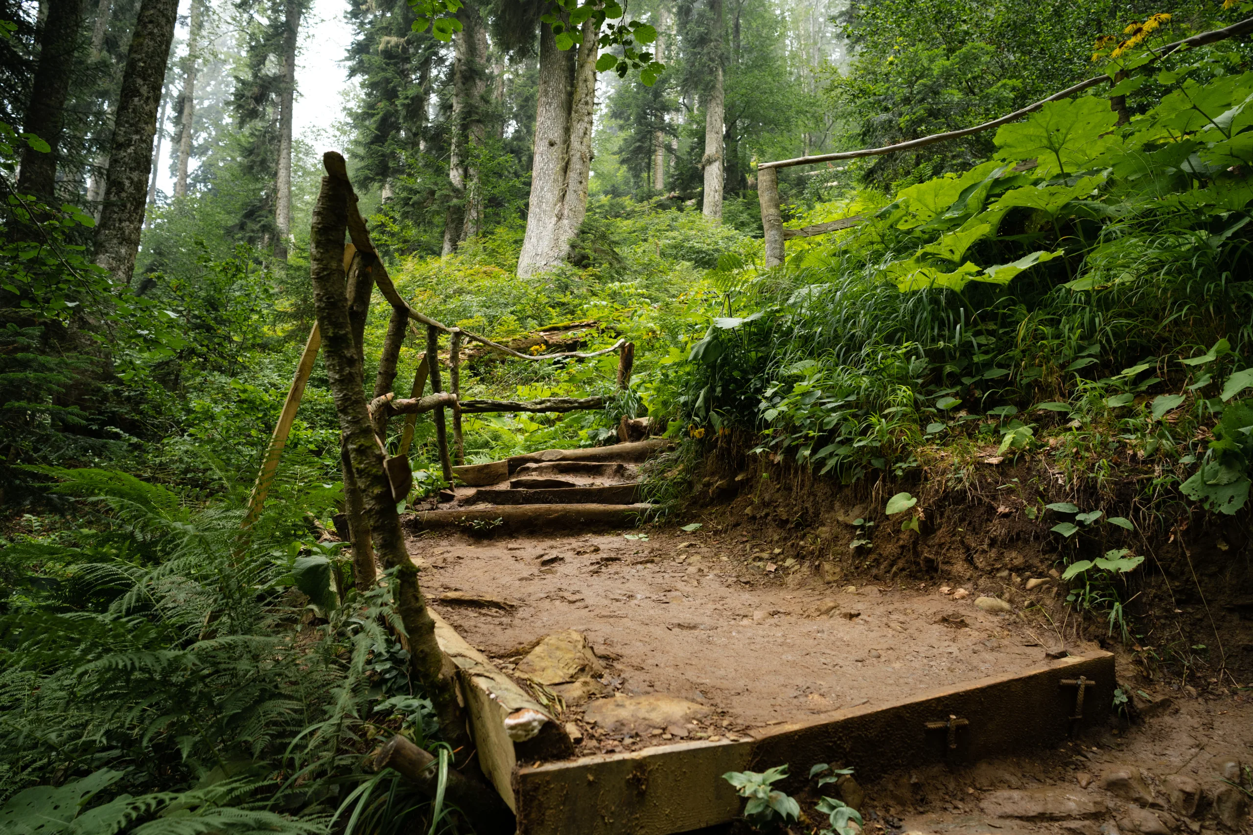
Galster Wilderness Park Trails
One of the most popular hiking destinations in West Covina is Galster Wilderness Park. This natural preserve features a network of trails that wind through coastal sage scrub and oak woodlands. The main loop trail is relatively short but offers moderate elevation gain, making it ideal for a quick workout or a weekend nature walk. Along the way, hikers can enjoy shaded sections, seasonal wildflowers, and occasional wildlife sightings. Because the park is easily accessible and well-maintained, it is a top choice for families and beginners who still want a bit of adventure.
Big Dalton Canyon And Nearby Connections
Although technically in nearby Glendora, Big Dalton Canyon is close enough to be a favorite for West Covina residents. The canyon’s trail system offers a peaceful, creekside environment with towering trees and picturesque bridges. Trails range from easy to moderate, allowing you to tailor your hike to your fitness level. Additionally, several paths connect to longer routes in the foothills, making it a strategic starting point for more serious hikers. As a result, Big Dalton Canyon serves as a versatile option for both casual walkers and seasoned outdoor enthusiasts.
Schabarum Skyline Trail Access
Another notable option near West Covina is the Schabarum Skyline Trail, a long-distance trail that traverses the Puente Hills. While not entirely within city limits, various access points are only a short drive away. This trail rewards hikers with far-reaching views of the San Gabriel Valley, especially at sunrise and sunset. Its rolling terrain provides a solid cardio workout, and the wide pathways are suitable for both hikers and trail runners. For those willing to travel just beyond West Covina, this route adds variety and challenge to any regular hiking routine.
Comparison Of Top Hiking Options
To help you choose the best hike for your needs, the table below compares key features of the most popular trails accessible from West Covina.
| Trail / Area | Approx. Difficulty | Highlights | Best For |
|---|---|---|---|
| Galster Wilderness Park | Easy to Moderate | Shaded paths, local wildlife, city views | Families, beginners, quick workouts |
| Big Dalton Canyon | Easy to Moderate | Creekside scenery, bridges, wooded areas | Nature lovers, casual hikers |
| Schabarum Skyline Trail | Moderate | Ridge views, long-distance route, rolling hills | Fitness hikers, trail runners |
Tips For Enjoying West Covina Hiking Trails
To make the most of the best hiking trails in West Covina, remember a few essential tips. Always check the weather before you head out, and carry plenty of water, especially during warmer months. Proper footwear will help you navigate uneven terrain comfortably, while sun protection is crucial on exposed ridgelines. Additionally, practice Leave No Trace principles by packing out all trash and staying on designated paths to protect the natural environment.
Conclusion
From the accessible paths of Galster Wilderness Park to the scenic routes of Big Dalton Canyon and the expansive Schabarum Skyline Trail, West Covina and its surrounding areas offer a variety of memorable hiking experiences. These trails provide an excellent way to stay active, enjoy fresh air, and appreciate Southern California’s natural beauty. By choosing the routes that best match your skill level and interests, you can turn every outing into a rewarding adventure in West Covina, CA.
Finding the Best Hiking Trails in West Covina, CA
How can I find the best beginner-friendly hiking trails in West Covina, CA?
For beginner-friendly hiking in West Covina, focus on local parks and shorter, well-marked paths. Galster Wilderness Park and Shadow Oak Park are popular starting points because they offer relatively gentle terrain and clear signage. Use trail platforms such as AllTrails, REI Hiking Project, or Google Maps to filter routes by “Easy” difficulty and distance under 3 miles. Read recent user reviews to confirm current conditions, shade coverage, and any steep sections. Starting early in the morning, carrying enough water, and wearing supportive footwear will make these beginner routes more enjoyable and safer.
Which resources are most reliable for researching hiking trails near West Covina?
Reliable research starts with established hiking and outdoor platforms, such as AllTrails, Gaia GPS, and the REI Co-op trail finder, which provide maps, elevation profiles, photos, and recent reviews. Cross-check that information with official sources like Los Angeles County Parks and Recreation or City of West Covina park pages for current rules, closures, and parking details. Local hiking clubs and social media groups focused on the San Gabriel Valley or San Gabriel Mountains can offer first-hand reports about trail difficulty, crowd levels, and seasonal issues like heat or mud. When possible, compare at least two sources before committing to a new trail.
What factors should I consider when choosing a hiking trail in or near West Covina?
Choose a trail by matching it to your fitness level, experience, and the day’s weather. Key factors include distance, total elevation gain, and surface type, which determine how strenuous the hike will feel. In West Covina and the surrounding foothills, many routes are exposed, so consider shade, sun exposure, and forecasted temperatures, especially in summer. Check for amenities such as restrooms, water fountains, and parking availability. Review whether dogs are allowed, if there are any permit or parking fees, and typical crowd levels at your planned time of day. Finally, confirm cell service or download offline maps in case coverage is limited in nearby canyons or hills.
When is the best time of year and day to hike in West Covina, CA?
The most comfortable seasons for hiking in West Covina are late fall through spring, when temperatures are cooler and the air is clearer. Winter and early spring can offer greener hillsides and wildflowers on nearby foothill trails. During hot summer months, it is safer to hike early in the morning or near sunset to avoid peak heat and direct sun. Check the local weather forecast for high temperatures, wind, and any air quality alerts, especially after regional wildfires. Regardless of the season, plan to start earlier for longer hikes and carry extra water, sun protection, and a hat due to the region’s frequent sun exposure.
How can I stay safe while exploring hiking trails around West Covina?
Safety begins with choosing a trail that matches your physical condition and experience, then telling someone your route and expected return time. Bring more water than you think you need, along with snacks, a fully charged phone, a basic first-aid kit, and sun protection. Wear sturdy, closed-toe shoes with good traction, as many local trails include loose dirt or small rocks. Stay on marked paths to avoid getting lost and to reduce encounters with wildlife such as snakes. Be aware of heat illness symptoms, rest in the shade when needed, and turn back if you feel unwell or conditions change. Finally, review any posted rules at the trailhead and follow Leave No Trace principles to protect the local environment.


latest video
news via inbox
Sign up to get local tips delivered to your inbox.


