Best Hiking Trails in San Dimas, CA
Best Hiking Trails In San Dimas CA
San Dimas, CA offers some of the best hiking trails in the San Gabriel Valley, attracting outdoor enthusiasts seeking scenic views, peaceful nature, and accessible adventure. Nestled near the foothills, this charming city features a variety of well-maintained paths ideal for both beginners and experienced hikers. From gentle, family-friendly routes to more challenging climbs with rewarding vistas, San Dimas hiking trails provide a perfect escape from urban life while remaining conveniently close to Los Angeles. As you explore this guide, you will discover popular destinations such as Bonelli Regional Park and nearby canyon routes, all known for their diverse landscapes and abundant wildlife. Additionally, many of these trails offer opportunities for bird-watching, trail running, and photography, making them versatile options for outdoor recreation. With this overview, you’ll be well-prepared to choose the top hiking trails in San Dimas, CA that match your interests and fitness level.


Introduction
San Dimas, CA, nestled at the foothills of the San Gabriel Mountains, offers some of the best hiking trails in Southern California. With scenic canyon paths, lake views, and family-friendly routes, this charming city is a hidden gem for outdoor enthusiasts. Whether you are a beginner hiker or an experienced trail seeker, San Dimas provides a variety of options that combine natural beauty with easy access. Below, we explore the top hiking trails in San Dimas and highlight what makes each one worth visiting.
Frank G Bonelli Regional Park Trails
One of the most popular hiking destinations in San Dimas is Frank G. Bonelli Regional Park. Surrounding Puddingstone Lake, this extensive park features multiple interconnecting trails with scenic water views. The trails range from flat lakeside paths to rolling hills, offering options for both casual walkers and fitness-focused hikers. Because the park is well maintained and offers restrooms, picnic areas, and parking, it is ideal for families and group outings. Additionally, the lake views at sunrise and sunset provide excellent photo opportunities for nature lovers.
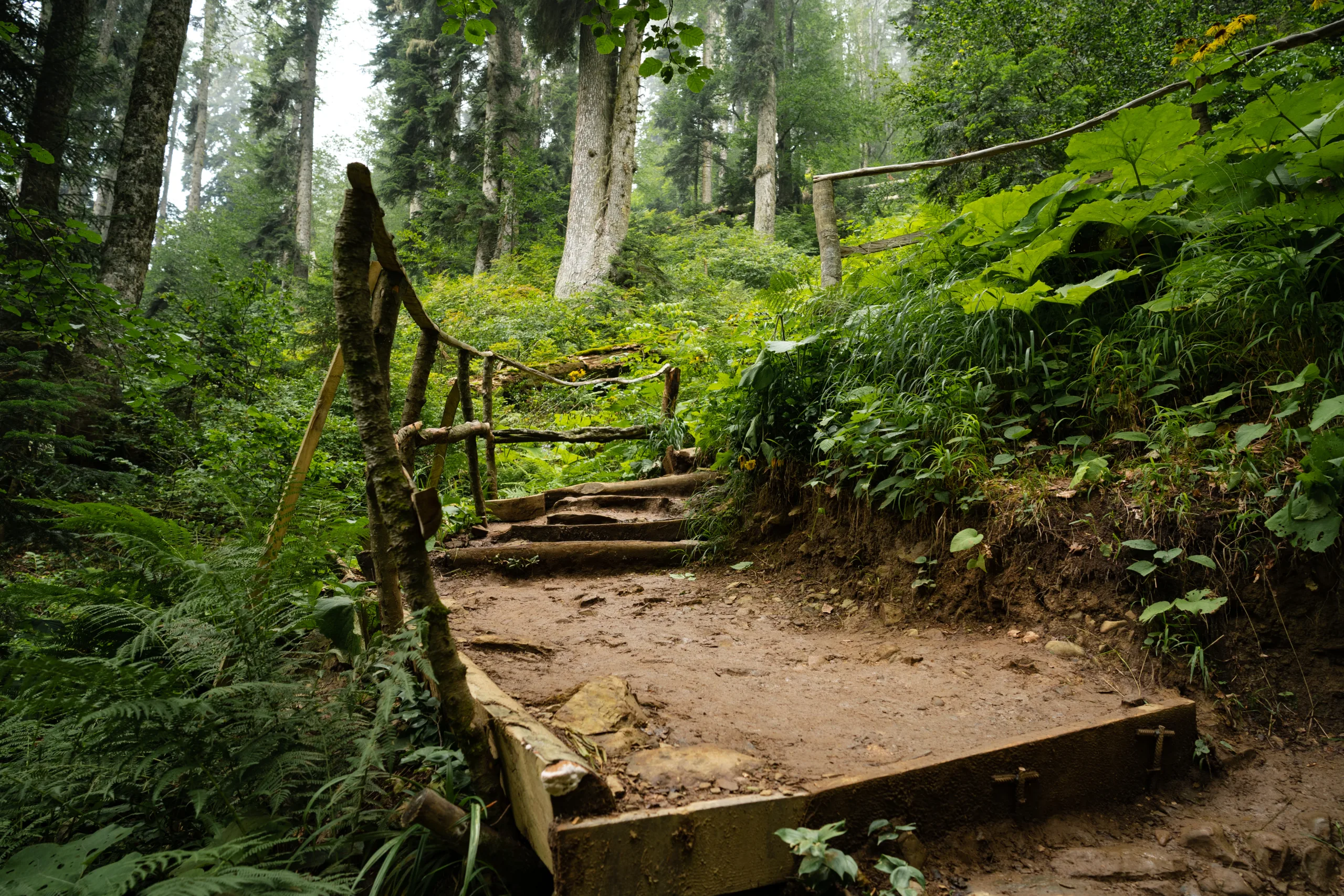
San Dimas Canyon Nature Center Trails
For those who enjoy a more natural and educational experience, the San Dimas Canyon Nature Center area is a perfect choice. This network of trails winds through native chaparral, oak woodlands, and seasonal creeks. Along the way, hikers can learn about local wildlife and plants through interpretive signs near the Nature Center. The main loop trails are moderately easy, making them suitable for beginners and children. Furthermore, the shaded sections of the trail offer relief during warmer months, while scenic canyon views reward visitors year-round.
Walnut Creek And Local Connector Trails
In addition to the major parks, San Dimas features several connector trails that link neighborhoods, parks, and nearby cities. Trails around Walnut Creek and local greenbelts provide peaceful routes perfect for morning walks, jogging, or biking. These smaller paths may not be as dramatic as mountain hikes, but they still deliver a relaxing outdoor experience close to home. Many residents use these trails daily, which has helped establish San Dimas as a walkable and recreation-friendly community.
Comparison Of Top San Dimas Hiking Trails
To help you choose the right path for your next adventure, the following table compares some of the best hiking trails in San Dimas, CA based on difficulty, scenery, and typical uses.
| Trail | Location | Difficulty | Highlights |
|---|---|---|---|
| Bonelli Park Lakeside Trails | Frank G. Bonelli Regional Park | Easy to Moderate | Lake views, paved and dirt options, family-friendly |
| San Dimas Canyon Loop | San Dimas Canyon Nature Center | Easy | Nature center access, shaded areas, wildlife viewing |
| Walnut Creek Connector Trails | Various Neighborhood Access Points | Easy | Urban greenbelts, jogging and biking, dog-friendly |
Tips For Hiking In San Dimas
Because San Dimas experiences warm, dry weather much of the year, it is important to hike prepared. Always bring water, sun protection, and appropriate footwear, especially on longer routes around Bonelli Park. Starting early in the morning helps you avoid midday heat and ensures easier parking. Additionally, staying on marked trails protects both you and the local ecosystem, which includes sensitive plant and animal habitats.
Conclusion
From lakeside paths at Frank G. Bonelli Regional Park to educational routes at San Dimas Canyon Nature Center, the city offers a surprisingly wide range of outdoor options. These San Dimas hiking trails deliver accessible nature, scenic views, and family-friendly recreation just minutes from residential neighborhoods. By exploring these well-maintained routes and planning ahead for weather and trail conditions, you can fully enjoy everything San Dimas, CA, has to offer for hikers of all skill levels.
Finding the Best Hiking Trails in San Dimas, CA
How can I find the best hiking trails in San Dimas, CA for my skill level?
Start by checking reputable trail platforms such as AllTrails, Hiking Project, or local park websites that list trails around San Dimas, including Frank G. Bonelli Regional Park and Walnut Creek Community Regional Park. Filter by difficulty (easy, moderate, hard), distance, and elevation gain to match your fitness level. Read recent reviews to see if conditions have changed, and look at trail maps to confirm whether there are steep sections, exposed ridges, or water crossings. When in doubt, begin with shorter, well-marked loops and gradually work up to longer or steeper routes as your experience grows.
What are some popular hiking areas in and around San Dimas, CA?
Popular hiking areas in and near San Dimas include Frank G. Bonelli Regional Park, which offers lakeside trails and rolling hills, and the Walnut Creek Community Regional Park area with multi-use paths connecting to the wider trail network. To the north and northeast, hikers often explore routes that connect toward Marshall Canyon, Claremont Hills, and the foothills of the San Gabriel Mountains for more elevation and longer outings. These areas provide a range of trail types, from casual family-friendly walks to more challenging climbs with panoramic views of the San Gabriel Valley.
When is the best time of year and day to hike in San Dimas, CA?
The most comfortable seasons for hiking in San Dimas are fall, winter, and spring, when temperatures are cooler and visibility is often clearer. During the hotter summer months, early morning hikes are strongly recommended to avoid peak heat and sun exposure. Aim to start your hike shortly after sunrise, bring sufficient water, and plan to be off the trail by late morning or early afternoon on very warm days. Always check the local weather forecast for heat advisories or high winds before heading out, and adjust your route and timing accordingly.
What should I look for in an online trail description before choosing a hike in San Dimas?
Review the total distance, elevation gain, and estimated completion time to be sure the hike matches your fitness and time constraints. Check whether the trail is a loop, out-and-back, or point-to-point, and confirm the exact trailhead location and parking situation. Look at photos and maps to assess trail surface, shade, and exposure, and read the most recent user comments for updates on closures, overgrowth, or muddy sections. It is also useful to confirm whether dogs, bikes, or horses share the trail, and whether permits or parking fees apply within San Dimas or nearby parks.
What safety tips should I follow when hiking trails in San Dimas, CA?
Bring more water than you think you will need, especially in warm weather, and wear sturdy footwear suitable for uneven terrain. Tell someone your planned route and expected return time, and carry a fully charged phone along with a downloaded offline map in case cell service is limited. Stay on marked trails to avoid getting lost and to protect local habitat, and be aware of common Southern California hazards such as loose rocks, hot sun, and potential encounters with snakes. Check local park or county websites for fire danger levels, trail closures, or wildlife advisories before you go, and turn back if conditions seem unsafe or beyond your comfort level.


latest video
news via inbox
Sign up to get local tips delivered to your inbox.


