Best Hiking Trails in La Verne, CA
Best Hiking Trails In La Verne CA
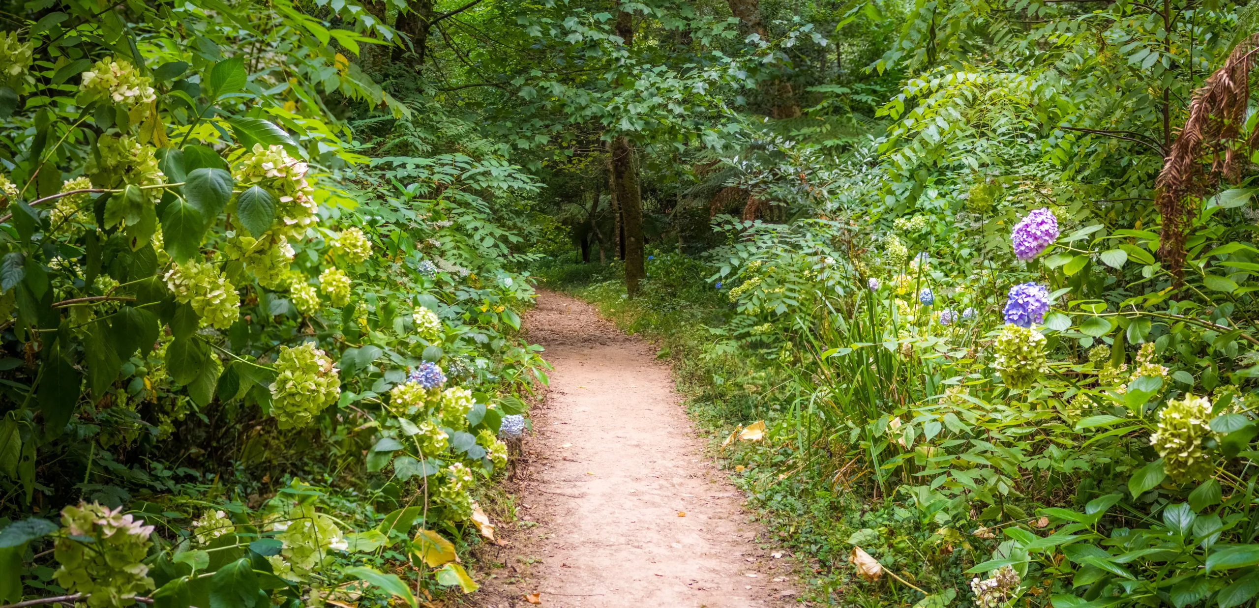
La Verne, CA offers some of the most scenic and accessible hiking trails in the San Gabriel Valley, making it a prime destination for outdoor enthusiasts of all skill levels. Nestled against the picturesque foothills, this charming city provides a diverse range of trails that feature panoramic mountain views, peaceful canyon pathways, and opportunities to observe local wildlife. From family-friendly walks to more challenging ascents, La Verne hiking trails cater to both casual walkers and serious trekkers. Moreover, their convenient proximity to major freeways and urban amenities makes planning a day hike both simple and rewarding. As you explore the area, you’ll discover well-maintained paths, clearly marked trailheads, and ample parking, which all contribute to a stress-free outdoor experience. In the following sections, we will highlight the best hiking trails in La Verne, helping you choose the perfect route for your next adventure.


Introduction
Located at the foothills of the San Gabriel Mountains, La Verne, CA offers some of the best hiking trails in the Inland Empire. With its mix of scenic canyon paths, challenging mountain climbs, and family-friendly loops, La Verne is a prime destination for outdoor enthusiasts. Whether you are a casual walker or an experienced hiker, the city’s trail network provides excellent opportunities for exercise, photography, and nature appreciation.
Top Hiking Trails In La Verne CA
To help you plan your next outdoor adventure, the following table highlights some of the best hiking trails in La Verne, CA, including distance, difficulty, and key features.
| Trail Name | Distance (Round Trip) | Difficulty | Highlights |
|---|---|---|---|
| Marshall Canyon Trail | 5–10 miles (varies) | Moderate | Shaded canyon, creek crossings, wildlife |
| Claremont Hills Wilderness Loop (nearby) | 5 miles | Moderate | Panoramic city and mountain views |
| Potato Mountain Via Evey Canyon | 4.5 miles | Moderate to Strenuous | Summit views, classic local peak |
| Marshall Canyon Equestrian Trails | 2–4 miles | Easy to Moderate | Gentle grades, good for beginners |
Marshall Canyon Trail
The Marshall Canyon Trail is one of La Verne’s signature hiking destinations. Beginning near the Marshall Canyon Golf Course, this trail follows a shaded canyon with seasonal streams, making it especially appealing during warmer months. The path offers a series of gentle climbs and descents, suitable for hikers, trail runners, and mountain bikers.
As you move deeper into the canyon, you will notice oak woodlands, deer, and a variety of bird species. Because the trail connects to other routes in the foothills, you can easily customize your distance, extending your hike toward Claremont or San Dimas. This flexibility makes Marshall Canyon ideal for both shorter family outings and longer training hikes.
Claremont Hills Wilderness Loop
Just a short drive from La Verne, the Claremont Hills Wilderness Loop is a popular option for residents seeking a well-maintained loop with rewarding views. The 5-mile circuit features wide fire roads and consistent elevation gain, providing an excellent workout without technically challenging terrain.
From the higher sections of the loop, hikers enjoy sweeping vistas of La Verne, the Pomona Valley, and on clear days, even downtown Los Angeles. Because this trail is heavily used, it is also a great choice for those who prefer a busier, more social hiking environment. Arriving early in the morning helps you avoid crowds and high temperatures.
Potato Mountain Via Evey Canyon
For hikers looking for a slightly more demanding experience, Potato Mountain via Evey Canyon is a classic local summit hike accessible from the outskirts of La Verne. The trail begins in a shaded canyon and quickly transitions into steeper, exposed switchbacks leading to the summit.
At the top, you are rewarded with impressive views of the San Gabriel Mountains and the valley floor. While the distance is moderate, the elevation gain can be challenging, so this route is best suited for hikers with a reasonable level of fitness. Bringing adequate water and sun protection is essential, especially during summer months.
Tips For Hiking In La Verne CA
To fully enjoy the best hiking trails in La Verne, CA, it is important to plan ahead. Start hikes early to avoid midday heat, particularly on exposed ridgelines. Always carry plenty of water, wear sturdy footwear, and use sunscreen and a hat. Additionally, be mindful of local wildlife and stay on designated paths to protect the natural environment.
Most importantly, check trail conditions and parking regulations before you go. Some areas may require permits or have limited parking, especially on weekends. Respecting trail etiquette and packing out all trash helps preserve these beautiful routes for future visitors.
Conclusion
From the shaded serenity of Marshall Canyon Trail to the panoramic rewards of Potato Mountain, La Verne, CA offers a diverse range of hiking experiences. These trails provide not only physical benefits, but also opportunities to connect with nature and enjoy stunning views of the San Gabriel foothills. By choosing the right route for your skill level and preparing appropriately, you can make the most of the top hiking trails in La Verne, CA and enjoy memorable adventures just minutes from the city.
Finding the Best Hiking Trails in La Verne, CA
How can I find the best hiking trails near La Verne, CA for my skill level?
Start by using reputable trail platforms such as AllTrails, Hiking Project, or local park district websites and filter by distance, elevation gain, and difficulty (easy, moderate, hard). For La Verne specifically, look for trails within the San Gabriel Mountains foothills and near the Angeles National Forest boundary.
Review recent user comments for current conditions, closures, and hazards. Pay attention to total distance, elevation gain, and trail type (out-and-back, loop, or point-to-point). If you are new to hiking, aim for under 5 miles with less than 800–1,000 feet of elevation gain. Intermediate hikers can look for 5–8 miles with up to 2,000 feet of gain. Always compare trail stats with your current fitness level and check topographic maps to understand how steep the climbs are before choosing a route.
What are some popular hiking areas in and around La Verne, CA?
La Verne offers access to several well-known trail areas in the foothills of the San Gabriel Mountains. Popular local spots include the Marshall Canyon area, which provides a network of interconnected trails suitable for easy to moderate hikes, and the trails above Live Oak Canyon, known for oak woodlands and canyon views.
Nearby, the Claremont Hills Wilderness Park is a short drive away and features a well-maintained loop with good signage and parking, often used by local residents for fitness hikes. You can also explore the lower sections of the Angeles National Forest to access longer and more challenging routes with higher elevation and expansive views. Check city and county park websites, as well as the U.S. Forest Service site, for maps, trail descriptions, and any permits or parking passes required before heading out.
When is the best time of year to hike in La Verne, CA?
The best seasons for hiking in La Verne are fall, winter, and spring, when temperatures are cooler and visibility is generally better. From late October through April, you will usually experience more comfortable daytime highs, making uphill climbs safer and more enjoyable. This is also when you are more likely to see green hillsides and seasonal wildflowers after winter rains.
Summer hikes can be rewarding but require extra caution due to heat, sun exposure, and dry conditions. If you hike in late spring or summer, start as early as sunrise, choose shaded routes where possible, and carry more water than you think you need. Always check the local weather forecast, air quality reports, and fire danger levels; in periods of extreme heat or high fire risk, it is advisable to shorten your hike or postpone it. Trail and forest closures may occur during wildfire season, so verify access with local authorities before driving to the trailhead.
What should I look for in online trail reviews for La Verne hikes?
Focus on recent reviews, ideally posted within the last few weeks, as conditions around La Verne can change quickly with heat, storms, or maintenance work. Look for comments about trail surface (rocky, rutted, overgrown), shade coverage, and water sources, as well as notes on parking availability, crowd levels, and safety concerns such as wildlife, loose footing, or steep drop-offs.
Pay close attention to reviewers with a similar fitness level or hiking style to yours. Many platforms allow users to share their experience level, photos, and GPS tracks; use those to compare the posted statistics with real-world experiences. Confirm whether the trail is well-marked, whether there is cell service, and whether any permits, fees, or specific parking passes are required at the trailhead near La Verne or in adjacent areas like Claremont and the Angeles National Forest. Consistent mentions of the same issue across multiple reviews are strong indicators of what you should expect on the trail.
How can I stay safe while hiking the trails around La Verne, CA?
Begin by choosing trails that match your fitness and experience, and let someone know your planned route and expected return time. In the La Verne area, heat, sun, and dry conditions are common, so carry ample water, wear sun protection (hat, sunscreen, sunglasses), and avoid hiking during the hottest part of the day. Proper footwear with good traction is important, as many foothill trails can be dusty, rocky, or uneven.
Bring a basic kit that includes a charged phone, offline map or printed map, snacks, a small first-aid kit, and a lightweight extra layer. Stay on marked trails to protect local habitats and reduce your risk of getting lost or encountering unstable terrain. Watch for local wildlife, such as rattlesnakes, and give them plenty of space. Before you leave, verify trail conditions, closures, and fire danger levels with the city of La Verne, the county, or the U.S. Forest Service. If conditions look marginal due to heat, smoke, or storms, choose a shorter route or reschedule your hike to a safer time.


latest video
news via inbox
Sign up to get local tips delivered to your inbox.


