Best Hiking Trails in La Crescenta, CA
Best Hiking Trails In La Crescenta CA
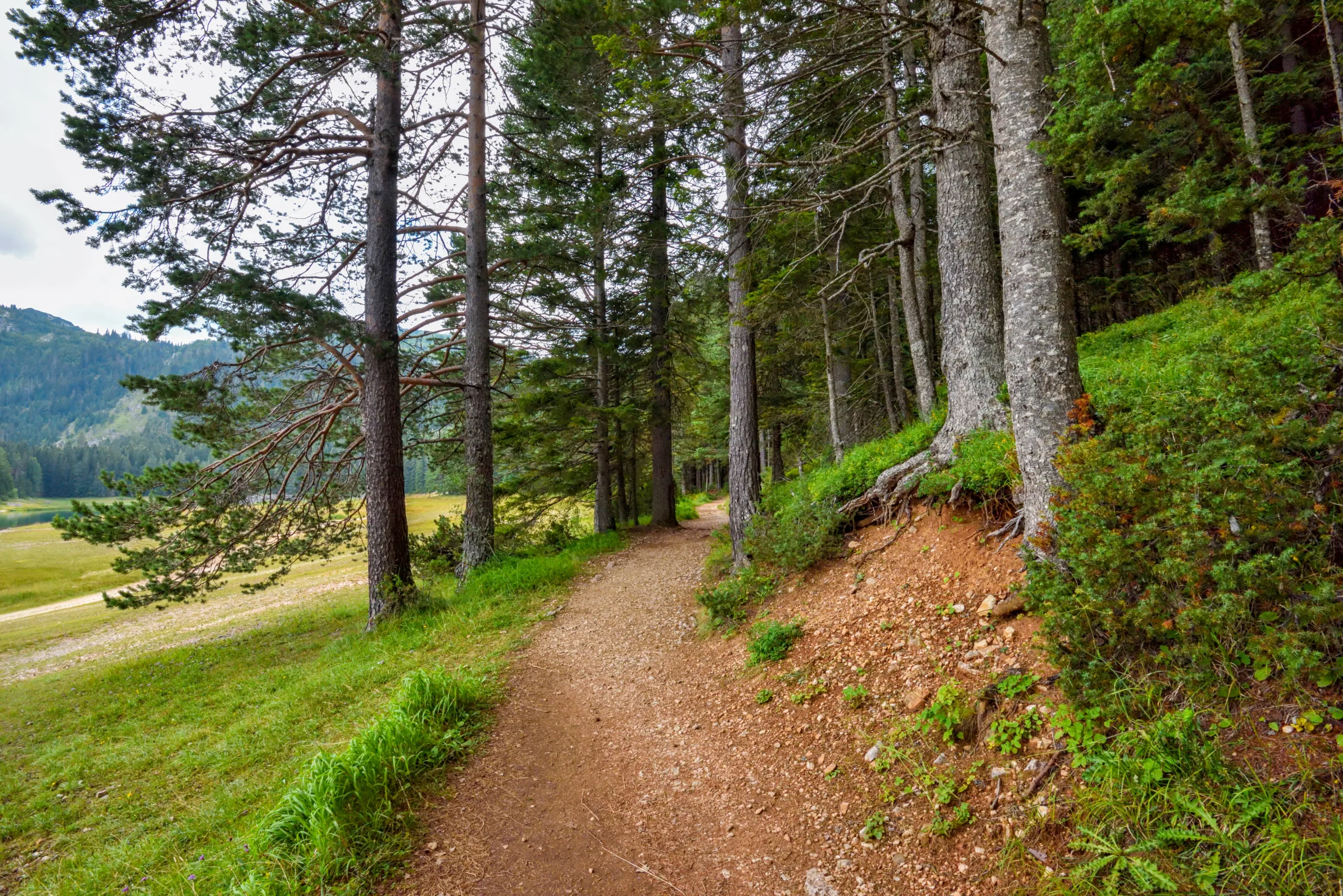
Nestled against the scenic **San Gabriel Mountains**, La Crescenta, CA offers some of the **best hiking trails in Southern California** for outdoor enthusiasts of all skill levels. From gentle, family-friendly paths to more challenging canyon climbs, this foothill community provides a **diverse range of hiking experiences** with sweeping vistas, seasonal wildflowers, and abundant wildlife. Conveniently located near Los Angeles, La Crescenta’s trails are ideal for hikers seeking a quick escape into nature without a long drive. As you explore the area, you’ll discover **well-maintained routes**, shaded oak groves, and panoramic overlooks perfect for photography and quiet reflection. In the following sections, we will highlight the **top La Crescenta hiking trails**, share insider tips on parking and trail conditions, and help you choose the right route for your next adventure, ensuring a safe, enjoyable, and memorable day on the trail.


Introduction
La Crescenta, CA is a gateway to some of the best hiking trails in the San Gabriel Mountains. Nestled between Los Angeles and the Angeles National Forest, this community offers scenic routes for beginners and experienced hikers alike. From panoramic vistas to shaded canyon paths, the hiking options near La Crescenta provide a perfect escape into nature while remaining close to the city. In this guide, we will explore the top trails, highlight key features, and help you choose the best route for your next outdoor adventure.
Why Hike In La Crescenta
Hiking in La Crescenta combines convenience, natural beauty, and year-round accessibility. The area’s trail network delivers stunning views of the Crescenta Valley, downtown Los Angeles, and the rugged San Gabriel peaks. Additionally, many trailheads are just a short drive from residential neighborhoods, making it easy to fit a rewarding hike into a busy schedule. With generally mild weather and a variety of terrain, La Crescenta is an excellent destination for fitness hikes, family outings, and photography excursions.
Best Hiking Trails In La Crescenta
Several standout trails near La Crescenta offer unique experiences, from gentle fire roads to challenging climbs. Below is an overview of some of the most popular and scenic hiking trails in the area to help you plan your next outing.
| Trail Name | Approx. Distance (Round-Trip) | Difficulty | Key Features |
|---|---|---|---|
| Deukmejian Wilderness Park Trails | 2–7 miles | Easy to Moderate | Canyon views, nature center, family-friendly routes |
| Dunsmore Canyon And Le Mesnager Loop | 3–4 miles | Moderate | Creek crossings, shaded sections, historic stone barn |
| Mount Lukens Via Crescenta View | 9–10 miles | Strenuous | Summit views, steep climbs, rewarding vistas |
| Haines Canyon And Sister Elsie Peak Access | 6–8 miles | Moderate to Difficult | Rugged terrain, quiet canyons, forest scenery |
Deukmejian Wilderness Park Trails
Located just above La Crescenta, Deukmejian Wilderness Park offers a network of well-maintained, family-friendly trails. Routes like the Dunsmore Canyon Trail and the Le Mesnager Loop provide gradual elevation gain, making them ideal for beginners and casual hikers. Along the way, you will enjoy chaparral-covered hillsides, seasonal wildflowers, and clear views of the valley below. The presence of a small nature center and picnic areas further enhances the park’s appeal for weekend outings.
Dunsmore Canyon And Le Mesnager Loop
Beginning near the foothills of La Crescenta, the Dunsmore Canyon and Le Mesnager Loop showcase a pleasing mix of shaded creek sections and open ridgeline views. This moderately challenging loop features compact dirt trails, a few rocky stretches, and occasional water flow in wetter months. The historic Le Mesnager stone barn adds a cultural highlight, making the hike both scenic and educational. Because of its manageable length, this trail is perfect for hikers looking for a rewarding morning or afternoon trek.
Mount Lukens Via Crescenta View
For more experienced hikers seeking elevation and distance, Mount Lukens via the Crescenta View route is a must-hike summit experience. As one of the highest points overlooking Los Angeles, Mount Lukens provides expansive 360-degree views on clear days. The trail climbs steeply through chaparral, switchbacks, and exposed ridges, offering a solid workout. While challenging, the sense of accomplishment at the summit and the sweeping vistas of the city and mountains make this route a favorite among local hikers.
Hiking Tips And Safety
Because many La Crescenta trails traverse sun-exposed slopes and rugged terrain, it is crucial to hike prepared. Always carry plenty of water, sun protection, and a trail map or GPS. Start early during warmer months to avoid midday heat, and check for any Angeles National Forest alerts or fire restrictions before you go. Additionally, sturdy footwear and basic first aid supplies can help prevent injuries on rocky sections. By following these simple guidelines, you can safely enjoy everything La Crescenta’s trails have to offer.
Conclusion
From the accessible paths of Deukmejian Wilderness Park to the demanding climb of Mount Lukens, La Crescenta offers diverse hiking experiences for every skill level. The area’s combination of scenic views, convenient trailheads, and varied terrain makes it a premier destination for outdoor enthusiasts in Southern California. As you plan your next hike, consider exploring one of these top trails and discover why La Crescenta continues to attract hikers seeking natural beauty just minutes from the city.
Finding the Best Hiking Trails in La Crescenta, CA
What are some of the best hiking areas in La Crescenta, CA for a variety of skill levels?
La Crescenta offers several popular trail areas suitable for different abilities. Deukmejian Wilderness Park is a favorite, with trails like the Dunsmore Canyon and Rim of the Valley Trail providing moderate climbs and scenic foothill views. The Crescenta View Trail and the Le Mesnager Loop are good options for intermediate hikers seeking elevation and viewpoints. For those willing to drive a short distance, nearby Angeles National Forest access points, such as the trails off Big Tujunga Canyon Road or near Angeles Crest Highway, offer more strenuous hikes with expansive mountain vistas. These areas collectively provide options ranging from easy family walks to challenging routes with significant elevation gain.
How can I determine which La Crescenta trail matches my fitness and experience level?
Start by reviewing distance, total elevation gain, and average grade for each trail, which are usually listed on park websites, trail apps, and regional hiking guides. Beginners should look for shorter trails with modest elevation gain, generally under 500–800 feet, and clear, well-marked paths such as the easier routes in Deukmejian Wilderness Park. Intermediate and advanced hikers can target longer trails with steeper climbs and rougher terrain, common on routes reaching into the Angeles National Forest. Check recent trip reports for comments on trail conditions, heat exposure, and navigation challenges, and always match those factors to your current fitness, experience with steep or rocky terrain, and comfort with route-finding.
Where can I find reliable information and maps for La Crescenta hiking trails?
Reliable information is available from several local and regional sources. The City of Glendale and Los Angeles County park websites often provide official maps, trail descriptions, and regulations for places like Deukmejian Wilderness Park. Reputable hiking platforms and apps offer GPS tracks, elevation profiles, and user reviews for many La Crescenta–area trails and Angeles National Forest routes. Local outdoor shops and hiking clubs can also provide printed maps and up-to-date information on closures, seasonal conditions, and lesser-known trailheads. When possible, cross-check information from at least two sources and download an offline map before heading out, especially for trails extending into the backcountry.
What safety considerations should I keep in mind when hiking around La Crescenta?
The foothills and nearby mountains can be hot, dry, and exposed, so carry sufficient water, wear sun protection, and avoid hiking during the hottest part of the day in summer. Check fire danger levels and any posted closures, as the region is prone to wildfires and related restrictions. Trails can become hazardous after heavy rain due to mud, rockfall, or washed-out sections, so review recent conditions before heading out. Wildlife such as rattlesnakes and occasionally bears or mountain lions may be present; remain alert, stay on established trails, and know basic encounter guidelines. Always tell someone your planned route and expected return time, carry a map or GPS, and bring a small first-aid kit and extra layers in case weather changes unexpectedly.
Are there family-friendly or beginner hikes in La Crescenta suitable for short outings?
Several La Crescenta–area trails work well for families and beginners. Deukmejian Wilderness Park offers shorter, well-maintained routes close to parking areas, with gentle grades and clear signage, making them suitable for children or new hikers. The lower portions of some foothill trails provide scenic walks without committing to the steeper upper sections, allowing you to turn around whenever you choose. Look for loop trails under three miles with limited elevation gain, shaded stretches, and access to restrooms and picnic areas near the trailhead. Starting with these easier options allows new hikers to gain confidence before progressing to longer or steeper routes in the surrounding foothills and national forest.


latest video

news via inbox
Sign up to get local tips delivered to your inbox.


