
Best Hiking Trails in Hacienda Heights, CA
Best Hiking Trails In Hacienda Heights CA
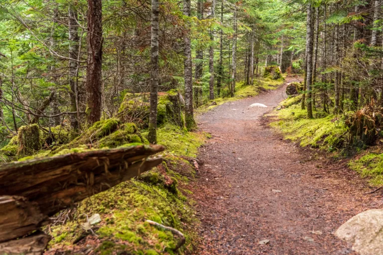
Nestled in the scenic foothills of eastern Los Angeles County, Hacienda Heights, CA offers some of the most accessible and rewarding hiking experiences in Southern California. From panoramic ridge walks to tranquil canyon paths, the area’s network of best hiking trails in Hacienda Heights attracts outdoor enthusiasts of all skill levels. As you explore this vibrant community, you’ll discover routes that showcase sweeping city views, native wildflowers, and shaded oak groves, all just minutes from suburban neighborhoods.
Whether you are a seasoned hiker seeking a challenging climb or a family looking for a leisurely weekend stroll, these Hacienda Heights hiking trails provide a perfect escape into nature. In the sections that follow, we will highlight key trail features, difficulty levels, and must-see viewpoints, helping you plan the ideal outing and make the most of your next hiking adventure in this picturesque Southern California destination.
Introduction
For outdoor enthusiasts in Southern California, the best hiking trails in Hacienda Heights, CA offer a refreshing escape from city life. Nestled against the scenic Puente Hills, this community features a variety of well-maintained trails that cater to beginners and seasoned hikers alike. From panoramic vistas to peaceful canyon paths, Hacienda Heights hiking options are ideal for fitness, photography, and nature exploration. In this guide, you will discover the top trails, essential highlights, and useful tips to help you plan your next adventure.
Turnbull Canyon Trail
The Turnbull Canyon Trail is one of the most popular hiking destinations near Hacienda Heights, CA. This moderate loop offers sweeping views of the San Gabriel Valley, downtown Los Angeles, and on clear days, even the Pacific Ocean. The trail is well-marked, making it an excellent choice for both intermediate hikers and those looking to advance their skills. Along the way, you will encounter rolling hills, shaded sections, and seasonal wildflowers, creating a diverse and visually appealing experience. Additionally, the trail’s proximity to residential areas makes it a convenient option for early morning or after-work hikes.
Schabarum Skyline Trail
Another standout route is the Schabarum Skyline Trail, which runs through the scenic Peter F. Schabarum Regional Park. This trail is especially popular with trail runners and hikers who enjoy longer, more continuous routes. As you ascend the ridgelines, you will be rewarded with expansive views of Hacienda Heights and the surrounding communities. The trail surface is primarily dirt, with steady inclines that provide a satisfying workout. Because the trail connects to other regional paths, it is also a great starting point if you wish to explore a broader network of hikes in the Puente Hills area.
Hsi Lai Temple And Local Nature Paths
For those interested in combining cultural exploration with outdoor activity, the area around the Hsi Lai Temple offers gentle walking paths and nearby access to hillside trails. While these routes are generally less strenuous, they provide a serene atmosphere perfect for reflective walks and family outings. The temple’s architecture and manicured gardens enhance the overall experience, making this area a unique hybrid of spiritual and natural beauty. In addition, the quieter environment and shorter paths are suitable for beginners or anyone seeking a low-intensity stroll.
Trail Comparison Table
| Trail Name | Difficulty | Approx. Distance | Key Features |
|---|---|---|---|
| Turnbull Canyon Trail | Moderate | 3–4 miles (loop options) | Panoramic city views, rolling hills, wildflowers |
| Schabarum Skyline Trail | Moderate to Challenging | 5+ miles (extendable) | Ridge-line vistas, fitness-focused, trail connections |
| Hsi Lai Temple Area Paths | Easy | 1–2 miles | Cultural scenery, gardens, relaxed walking routes |
Tips For Hiking In Hacienda Heights
To fully enjoy the best hiking trails in Hacienda Heights, it is important to prepare adequately. Start early in the morning to avoid midday heat, especially during summer. Always bring sufficient water, sunscreen, and a hat, as many sections of these trails offer limited shade. Wearing sturdy, closed-toe hiking shoes will help you manage uneven terrain safely. In addition, staying on designated paths protects local wildlife and helps preserve the natural ecosystem for future visitors. Checking weather forecasts and local trail conditions before you go will also ensure a safe and enjoyable outing.
Conclusion
From the challenging ascents of Turnbull Canyon to the tranquil paths near Hsi Lai Temple, Hacienda Heights, CA offers some of the most rewarding hiking experiences in the San Gabriel Valley. These trails combine scenic beauty, accessibility, and a range of difficulty levels, making them ideal for hikers of all backgrounds. By planning ahead and selecting the route that best matches your fitness and interests, you can make the most of your time on the trail. Ultimately, exploring the hiking trails in Hacienda Heights is an excellent way to stay active, connect with nature, and discover the hidden landscapes of this vibrant community.
Finding the Best Hiking Trails in Hacienda Heights, CA
What are some of the best hiking trails in Hacienda Heights for scenic views?
For scenic views in Hacienda Heights, the Turnbull Canyon trails are among the most popular, offering ridge-line paths with expansive city and canyon vistas. The Workman Mill Road to Turnbull Canyon loop provides steady elevation gain and panoramic views of the San Gabriel Valley. Another strong option is the Skyline Drive Fire Road access near Hacienda Hills, which features wide trails, rolling hills, and viewpoints ideal for sunrise and sunset. These trails are moderate in difficulty and are best enjoyed on clear days when visibility is highest.
Where can beginners find easy hiking trails in Hacienda Heights?
Beginners can start with the shorter and flatter segments of the Turnbull Canyon area, such as lower canyon routes accessed from Turnbull Canyon Road. These sections usually have gentler grades and well-defined paths. Trails connected to local parks, such as paths near Thomas Burton Park or along neighborhood greenbelts, also offer easier walking experiences with minimal elevation gain. When searching online, look for routes classified as “easy,” under three miles round-trip, and with less than 500 feet of total elevation gain to ensure they remain beginner-friendly.
How can I find reliable trail maps and information for Hacienda Heights hikes?
Reliable trail information for Hacienda Heights can be found through established hiking platforms and county resources. Online trail databases and apps, such as AllTrails or Hiking Project, typically include maps, recent reviews, photos, and route descriptions for Turnbull Canyon and nearby trail systems. In addition, checking the Los Angeles County Department of Parks and Recreation website can provide official trail notices, access points, and regulations. Cross-referencing at least two sources, and checking the latest user reviews for closures or conditions, helps ensure you have accurate and current information before you go.
When is the best time of day and year to hike in Hacienda Heights?
The best time of day to hike in Hacienda Heights is in the early morning or late afternoon, when temperatures are typically cooler and the lighting is better for views and photography. During summer, midday heat in exposed sections of Turnbull Canyon and surrounding hills can be intense, so starting before 9 a.m. is advisable. Spring and fall usually offer the most comfortable conditions, with greener hillsides in late winter and early spring after seasonal rainfall. In warmer months, choose shorter routes, bring extra water, and avoid hiking during extreme heat or poor air quality days.
What safety tips should I follow when hiking trails in Hacienda Heights?
When hiking in Hacienda Heights, stay on designated trails, especially in canyons and along ridgelines where footing can be uneven and steep. Carry sufficient water, sun protection, and a fully charged phone with an offline map of your route. Check weather forecasts and avoid hiking during extreme heat, heavy rain, or high-wind events, which can increase the risk of falls, heat-related illness, or falling branches. Inform someone of your planned route and expected return time, hike with a partner when possible, and respect posted signs regarding trail closures, wildlife, and private property boundaries. Staying aware of your surroundings, including cyclists and runners on shared paths, helps keep your hike safe and enjoyable.


latest video
news via inbox
Sign up to get local tips delivered to your inbox.

